Home

Welcome to the ‘IkeWai Marine CSEM survey! 

‘Ike Wai, means in Hawaiian “knowledge” and “water”, respectively. The mission of the IkeWai project is to ensure Hawaiʻi’s future water security through multidisciplinary research (e.g., geophysics, microbiology, biochemistry, hydrological modeling) to elucidate the groundwater systems in the island of Hawaiʻi. This large-scale project is funded by the National Science Foundation (NSF) EPSCoR program.

IkeWai-Logo_color

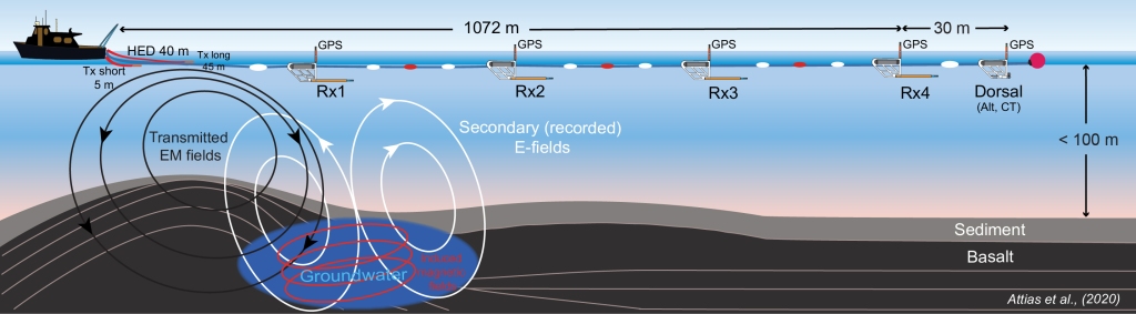
The marine geophysics component of this project used a newly developed surface-towed marine electromagnetic (EM) system and 2D inversion algorithms to study the spatial distribution and interconnectivity of the Hualalai groundwater system offshore the Kona coastline, the island of Hawai‘i. The surface-towed controlled-source EM (CSEM) data successfully imaged these submarine groundwater reserves’ electrical resistivity structure in high-resolution, embedded within complex volcanic geology that includes buried dikes, fault systems, lava tubes, and confined by impermeable ash/soil layers.

Download the full project description: IkeWaiMarineCSEM

IMG_0310
An example of a lava tube located adjacent to the Kona coastline, perpendicular to the offshore CSEM survey area.

The Survey Team:
Dr. Eric Attias – Chief scientist
Hawaiʻi Institute of Geophysics & Planetology
School of Ocean and Earth Science and Technology, University of Hawaiʻi

Dr. Dallas Sherman – Scientist
Scripps Institution of Oceanography
Frontier Geosciences, Inc.

Dr. Khaira Ismail – Scientist
Universiti Malaysia Terengganu

Jake Perez – Sr. Marine Mechanician
Electromagnetic laboratory
Scripps Institution of Oceanography

James Barry – P.E. Ocean Engineer, Hydrographer
Sea Engineering, Inc.

Jason Magalen – P.E. Hydrographer
Solmar Hydro

Brendan Hunter – Ocean Engineer
Sea Engineering, Inc.

Patrick Anderson – Ocean Engineer
Sea Engineering, Inc.

Max Sudnovsky – Huki Pono Captain
Sea Engineering, Inc.

Scientific Collaborations:
This marine study foster collaborations to harness the knowledge of leading scientists in the fields of marine EM, seafloor mapping, and rock physics modeling, including universities and research institutions from USA, Europe, and Southeast Asia. The marine EM laboratory at Scripps Institution of Oceanography (UCSD) provided the CSEM system and supported the data processing workflow. 2D CSEM forward and inverse modeling, as well as interpretation conducted in collaboration with researchers from the Lamont-Doherty Earth Observatory (Columbia University), and Woods Hole Oceanographic Institution. The multi-beam and backscatter datasets have been processed and analyzed in collaboration with researchers from the National Oceanography Centre (Southampton), and the Universiti Malaysia Terengganu. For submarine groundwater quantification, a rock physics modeling scheme has been applied in collaboration with scientists from the Jackson School of Geosciences, the University of Texas at Austin.

About

Controlled-source EM (CSEM) is an active-source electromagnetic technique that employs a deep or surface-towed horizontal electric dipole to generate electric and magnetic fields at low frequencies. The transmitted CSEM fields diffuse through the seafloor whereas the returning secondary fields are recorded by either ocean-bottom or fixed-towed electric receivers. The CSEM method is primarily sensitive to resistive structures at crustal depths.

Porpoise Array is a surface-towed CSEM system that comprises an onboard EM transmitter, horizontal electric dipole (HED) antenna, and an array of electric field receivers. This marine project utilized the Porpoise array to produce a resistivity tomography of the sub-seafloor, down to a depth of ~500 mbsf. The Porpoise CSEM system was developed and owned by the EM laboratory at the Scripps Institution of Oceanography.

Schematic illustration of the Porpoise surface-towed CSEM system. The system includes a 40 m horizontal electric dipole (HED) source that emits a current of 100 amps, and 4 Porpoise receivers at increment distance ~250 m to form a 1 km array. Each Porpoise includes a 2 m inline electric dipole, a data logger, and a GPS unit. At the end of the array, a Dorsal towed unit consists of an altimeter, conductivity/temperature measuring device and a GPS unit.

Additional marine geophysical datasets have been acquired using a high-resolution R2Sonic2024 multi-beam system and a G-882 marine magnetometer. These additional datasets helped us in mapping the seabed bathymetry and detect strong magnetic features such as dike systems. Additionally, the backscatter data provided information regarding the seafloor texture, whereas multi-beam data derived from the water column detected localized regions of prominent freshwater influx to the ocean.

The CSEM survey encompassed the entire offshore region that is parallel to the Hualalai terrestrial aquifer, acquiring data using 5 parallel survey lines (48 km each), and 5 perpendicular survey lines (1-3 km each). The total survey length is approximately  250 km.

Map_FINAL
The marine CSEM survey layout: The red lines denote the parallel survey towlines, whereas the black lines represent the survey crosslines. Right inset: Bathymetry/elevation map of the island of Hawaiʻi. The survey area is indicated by black rectangular.

The CSEM results derived from this study have been analyzed in a joint interpretation framework that included additional marine geophysical datasets (e.g., multi-beam, backscatter, and magnetic). Such an integrative approach has led to a broad understanding of the groundwater system in western Hawai‘i island, both onshore and offshore submarine regions. The resultant submarine resistivity models has been published in Science Advances (Attias et al., 2020) and are now available to the Hawai‘ian community, the board of water supply, and local stakeholders via the Ike Wai project web-based Gateway platform.

A short video describes our recent discovery of the transport mechanism of freshwater from onshore to offshore Hawai’i:

https://youtu.be/6dbKQbnpfoc

Link to the paper in Science Advances: https://advances.sciencemag.org/content/6/48/eabd4866

Blog

CSEM imaging of large-scale seafloor-to-ocean surface freshwater plumes

“Marine Electromagnetic Imaging and Volumetric Estimation of Freshwater Plumes Offshore Hawai’i”. In this paper, we present electromagnetic imaging of seafloor-to-ocean surface freshwater plumes (Attias et al., 2021, GRL: https://agupubs.onlinelibrary.wiley.com/doi/full/10.1029/2020GL091249). University of Hawai’i news article: https://www.hawaii.edu/news/2021/03/31/first-images-of-freshwater-plumes-at-sea/ Summary video of the project: https://www.youtube.com/watch?v=D0rqJXhgWas

Gallery


Contact

Please send me a message with your thoughts and impressions! Give me a call or email if you have any questions. I’ll be delighted to hear from you!

Eric
——————————————————
Eric Attias Ph.D.
Research Affiliate Faculty
Hawaiʻi Institute of Geophysics & Planetology
School of Ocean and Earth Science and Technology
University of Hawaiʻi at Mānoa
– – – – – – – – – – – – – – – – – – – – – – – – –
Tel: +1 (808) 829-6559
Email: attias@hawaii.edu
Website: www.ericattias.com

alex-perez-580371-unsplash